
Graw Meteorological Equipment
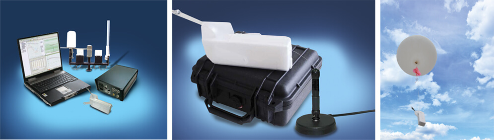
Shown Above:
GS-E Groundstation for office and vehicle use, GS-U Portable Groundstation with proven SDR receiver and integrated rechargable battery pack, and the DFM-09 digital GPS radiosonde.
Radiosondes and Radiosonde Data Processing Systems
GRAWMET Software
- User-friendly, intuitive operation and individually adjustable user interface
- Status viewlet for status notifications and visualisation of current sounding data
- Database-driven, graphical and tabular viewing and evaluation of meteorological measuring data
- Remote monitoring
Technical Data
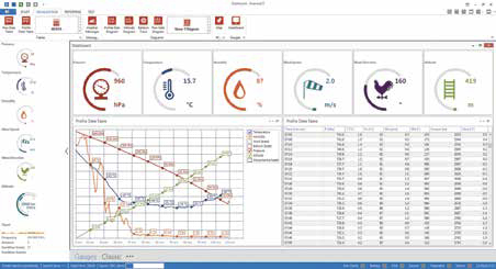
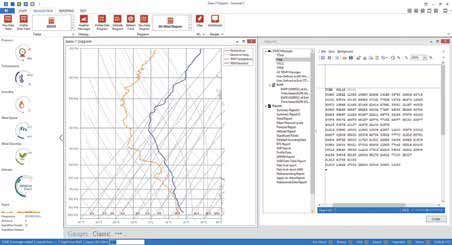
Graphics
Profile data, Altitude diagram, Flight map (Open Street Map, Bing) Tephigram, T-Log (P), Skew-T, Emagram, Stüve diagram, Balloon track, Hodograph
Messages
PILOT, TEMP, BUFR, CLIMAT
Weather indices
LFC, LCL, CCL, Showalter Index, CAPE, CINH, EL-Equilibrium Level, K-Index, Total Index, KO Index, Refractive Index, Modified Refractive Index
Reports
Customization, several output formats (text, pdf, csv, xls)
Statistics
Max/Min/Average values, Balloon Height statistic, Flight Path statistic
External sensors
Ozone functionality fully integrated, raw data output of other external sensors (XDATA, XML)
Data transmission
FTP, SFTP, SMS, Email, Sockets
Technical Specifications:
DFM-09 Radiosonde
Weight: < 90 g, ready to start
Size: 200 x 42 x 60 mm
Battery Lithium: Battery operating time > 140 min.
Wind finding: GPS (48 channels)
Transmission-rate: One full data set per second
Bandwidth: < 10 kHz
Frequency deviation: +/- 3 kHz
Modulation: FSK
Output power telemetry: 100 mW, typical
Error correction telemetry: Code-spreading, interleaving
Windfinding options: C/A code GPS
Temperature resolution: 0.1 °C
Temperature random error: < 0.2 °C
Humidity resolution: 1 % rH
Humidity random error: < 4 % rH
Pressure accuracy: < 0.3 hPa
Geopotential height accuracy: < 10 m
Wind speed accuracy: < 0.2 m/s
Accuracy horizontal position: < 5 m
Technical Specifications:
GS-E Groundstation
Weight: 3300 g
Size: 320 x 190 x 90 mm
Power supply: 110 … 250 V/AC 10 … 32 V/DC
Frequency range: 400 – 406 MHz
Connections:
2 x 400 MHz antennas
1 x GPS antenna
1 x GPS repeater
1 x USB connection for computer
1 x USB connection for radiosonde
Tuning steps: 20 kHz
Supported operating systems:
Windows® Vista, Windows® 7, Windows® 8
PC: Standard PC or notebook
GS-U Groundstation
Weight: 3900 g
Size: 270 x 245 x 120 mm
Power supply: Power adapter 100 … 240 V/AC / 12 V/DC 12 … 14 V
Runtime integrated battery pack: > 3 hours
Frequency range: 400 – 406 MHz
Connections:
1 x 400 MHz antenna
1 x USB
1 x power adapter
Tuning steps: 20 kHz
Receiving range: > 100 km
Protection: IP65 (waterproof)
PC: Standard PC or Notebook (Windows®)